


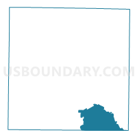
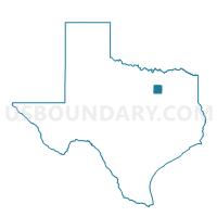
Voting District 3903, Dallas County, Texas
About
Outline

Summary
| Unique Area Identifier | 672064 |
| Name | Voting District 3903 |
| County | Dallas County |
| State | Texas |
| Area (square miles) | 45.63 |
| Land Area (square miles) | 45.00 |
| Water Area (square miles) | 0.63 |
| % of Land Area | 98.61 |
| % of Water Area | 1.39 |
| Latitude of the Internal Point | 32.58212380 |
| Longtitude of the Internal Point | -96.64614550 |
Maps

Graphs
Select a template below for downloading or customizing gragh for Voting District 3903, Dallas County, Texas


Neighbors
Neighoring Voting District (by Name) Neighboring Voting District on the Map
- Voting District 0017, Kaufman County, TX
- Voting District 0104, Ellis County, TX
- Voting District 0105, Ellis County, TX
- Voting District 0106, Ellis County, TX
- Voting District 0143, Ellis County, TX
- Voting District 3335, Dallas County, TX
- Voting District 3805, Dallas County, TX
- Voting District 3809, Dallas County, TX
- Voting District 3810, Dallas County, TX
- Voting District 3901, Dallas County, TX
- Voting District 3904, Dallas County, TX
- Voting District 3905, Dallas County, TX
Top 10 Neighboring County Subdivision (by Population) Neighboring County Subdivision on the Map
- Northeast Dallas CCD, Dallas County, TX (1,455,973)
- Southwest Dallas CCD, Dallas County, TX (912,166)
- Ferris CCD, Ellis County, TX (14,701)
- Crandall CCD, Kaufman County, TX (9,307)
Top 10 Neighboring Place (by Population) Neighboring Place on the Map
- Dallas city, TX (1,197,816)
- Lancaster city, TX (36,361)
- Seagoville city, TX (14,835)
- Red Oak city, TX (10,769)
- Hutchins city, TX (5,338)
- Wilmer city, TX (3,682)
- Ferris city, TX (2,436)
Top 10 Neighboring Unified School District (by Population) Neighboring Unified School District on the Map
- Dallas Independent School District, TX (1,020,846)
- Lancaster Independent School District, TX (36,347)
- Crandall Independent School District, TX (11,978)
- Ferris Independent School District, TX (9,562)
Top 10 Neighboring State Legislative District Lower Chamber (by Population) Neighboring State Legislative District Lower Chamber on the Map
- State House District 10, TX (184,699)
- State House District 4, TX (181,882)
- State House District 109, TX (175,255)
- State House District 110, TX (150,703)
Top 10 Neighboring State Legislative District Upper Chamber (by Population) Neighboring State Legislative District Upper Chamber on the Map
- State Senate District 2, TX (856,525)
- State Senate District 22, TX (789,412)
- State Senate District 23, TX (749,622)
Top 10 Neighboring 111th Congressional District (by Population) Neighboring 111th Congressional District on the Map
- Congressional District 6, TX (809,095)
- Congressional District 5, TX (725,642)
- Congressional District 30, TX (706,469)
Top 10 Neighboring Census Tract (by Population) Neighboring Census Tract on the Map
- Census Tract 508, Kaufman County, TX (9,307)
- Census Tract 170.01, Dallas County, TX (9,090)
- Census Tract 601.01, Ellis County, TX (7,626)
- Census Tract 601.02, Ellis County, TX (7,075)
- Census Tract 169.02, Dallas County, TX (5,563)
- Census Tract 169.03, Dallas County, TX (5,191)
- Census Tract 171.02, Dallas County, TX (4,786)
- Census Tract 168.02, Dallas County, TX (3,688)
Top 10 Neighboring 5-Digit ZIP Code Tabulation Area (by Population) Neighboring 5-Digit ZIP Code Tabulation Area on the Map
- 75217, TX (80,324)
- 75154, TX (36,041)
- 75119, TX (26,601)
- 75134, TX (20,276)
- 75253, TX (18,450)
- 75159, TX (18,339)
- 75146, TX (17,993)
- 75125, TX (6,691)
- 75141, TX (5,374)
- 75172, TX (3,956)